Meeruse sadam
Harju county and Tallinn · Soome laht
Página de este puerto en mervare.ee ↗
De un vistazo
- 6.3 mPermitted draughtpilot book
- 176 mMaximum lengthregister
- 24 mMaximum beamregister
- 5.2 mQuay depthregister
- Todo el añoNavigation periodregister
Here the published draught (6.3 m) is greater than the deepest quay depth (5.2 m): the sources disagree or measure different places. Confirm with the harbour before arriving.
Permitted draught is the limit the sailing directions publish for entering; quay depth is the register's figure for the deepest quay — other quays may be shallower. Neither guarantees a berth that suits your boat.
- laevade kogumahutavusega enam kui 100 üheaegne manööverdamineoriginal Estonian, not translated
- laeva ümberpaigutamine on lubatud üksnes sadamakapteni teenistuse loaloriginal Estonian, not translated
- laeva ümberpaigutamisel on lootsimine kohustuslik, v.a haalamisel laevadel pikkusega kuni 150 m kuni 150 m kauguseleoriginal Estonian, not translated
- 18 m/sNW- või N-tuule kiirusel üle18 m/soriginal Estonian, not translated
- 2,0 mlaine kõrgusel üle 2,0 moriginal Estonian, not translated
- 300 mnähtavusel alla 300 moriginal Estonian, not translated
Servicios
- Shore powerUnknown
- WaterUnknown
Precios y disponibilidad
Precio no publicado: consulte al puerto. Confirme con el puerto los precios, la disponibilidad en sus fechas y los servicios incluidos.
Acuerde directamente con el puerto la plaza, el precio y la llegada.
Llegada
Harju maakond, Tallinn, Põhja-Tallinna linnaosa, Kopliranna tn 49, 11713
Entorno del puerto
No apto para la navegación. Ver todos los puertos en el mapa.
View in Nutimeri (Transpordiamet, opens in a new tab) — Transpordiamet
Official navigation charts and markers, for information only — not a primary navigation aid.
Derrotero
Based on a published sailing directions guideSõidugraafiku järgi liikuval laeval on alati sadamasse sisenemise ja väljumise eesõigus. Väikelaevu ei teenindata. Väikelaevad peavad laevade lähenemisel hoiduma telgjoonest nii kaugele, kui seda võimaldab nende endi meresõiduohutus. Vessel movements: laevade kogumahutavusega enam kui 100 üheaegne manööverdamine; laeva ümberpaigutamine on lubatud üksnes sadamakapteni teenistuse loal; laeva ümberpaigutamisel on lootsimine kohustuslik, v.a haalamisel laevadel pikkusega kuni 150 m kuni 150 m kaugusele. Entry and departure ban: nW- või N-tuule kiirusel üle18 m/s; laine kõrgusel üle 2,0 m; nähtavusel alla 300 m.[2]
Utilizar junto con una carta náutica actualizada y los avisos a los navegantes.
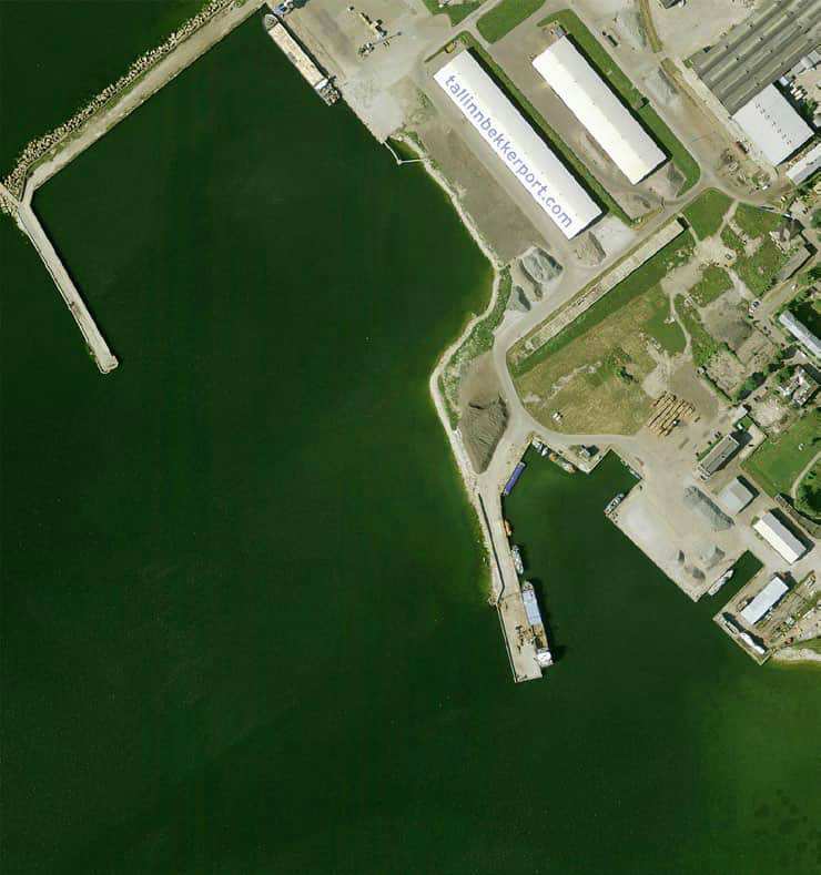
Depths and dimensional restrictions
The maximum permitted draught is 6.3 m. Published depths alongside range from 1.8 m to 5.2 m — shallowest at quay 7, deepest at quay 5. Depths are referenced to EH2000.[2]
Profundidades por muelle (11)
| quay 5 | 5.2 m |
|---|---|
| quay 1 | 4.1 m |
| quay 11 | 3.6 m |
| quay 3 and 4 | 2.8 m |
| quay 2 | 2.7 m |
| quay 9 and 10 | 2.2 m |
| quay 6 | 2.0 m |
| quay 7 and 8 | 1.8 m |
Fuentes
- Sailing directions Lootsiraamat 4.2 — Suurupi poolsaarest Kaberneeme poolsaareni
- Sailing directions Lootsiraamat 4.2 — Suurupi poolsaarest Kaberneeme poolsaareni
Publicado el 12 Sept 2026 · revisión 4
Estadísticas históricas del viento
Prevailing winds
How often the wind blew FROM each direction, May–September 2021–2025.
Modelled data, not measured at the harbour
Rings: May (inside) → Sep (outside). Figure at the edge: share of the whole season.
The wind most often came from W (12 % of the season's hours).
- under 3 %
- 3–6 %
- 6–9 %
- 9–13 %
- 13–20 %
- 20 % or more
Regional model data cannot show how sheltered the harbour is, or how the wind moves around its piers and breakwaters.
Data as a table
| Wind from | May | Jun | Jul | Aug | Sep | Season |
|---|---|---|---|---|---|---|
| N | 4.2 % | 4.3 % | 2.7 % | 3.3 % | 4.6 % | 3.8 % |
| NNE | 3.4 % | 2.0 % | 2.1 % | 1.9 % | 2.9 % | 2.5 % |
| NE | 4.2 % | 2.7 % | 4.1 % | 3.5 % | 2.5 % | 3.4 % |
| ENE | 6.2 % | 5.2 % | 7.8 % | 5.3 % | 4.7 % | 5.8 % |
| E | 4.2 % | 4.9 % | 4.0 % | 4.8 % | 5.7 % | 4.7 % |
| ESE | 3.5 % | 3.7 % | 3.0 % | 4.6 % | 5.3 % | 4.0 % |
| SE | 3.1 % | 3.4 % | 4.5 % | 5.8 % | 9.3 % | 5.2 % |
| SSE | 3.3 % | 3.8 % | 4.7 % | 8.1 % | 11 % | 6.2 % |
| S | 4.8 % | 4.7 % | 3.5 % | 7.1 % | 8.0 % | 5.6 % |
| SSW | 5.8 % | 6.4 % | 7.1 % | 9.2 % | 8.1 % | 7.3 % |
| SW | 7.1 % | 9.9 % | 13 % | 10 % | 8.5 % | 9.7 % |
| WSW | 12 % | 13 % | 14 % | 12 % | 6.8 % | 11 % |
| W | 16 % | 14 % | 12 % | 9.8 % | 5.6 % | 12 % |
| WNW | 10 % | 10 % | 8.4 % | 6.8 % | 5.5 % | 8.2 % |
| NW | 5.7 % | 7.3 % | 5.3 % | 4.2 % | 5.7 % | 5.6 % |
| NNW | 5.0 % | 3.6 % | 2.6 % | 3.4 % | 5.2 % | 3.9 % |
| calm | 0.9 % | 0.9 % | 1.0 % | 0.3 % | 0.4 % | 0.7 % |
| % | 100 % | 100 % | 100 % | 100 % | 100 % | 100 % |
Calm: below 0.5 m/s; counted in the total, not in any direction. 18360 valid hours of 18360 expected.
Source: ERA5 reanalysis (ECMWF / Copernicus Climate Change Service), ~25 km grid · model grid point 7 km north-east of the harbour (59.500, 24.750) · May–September 2021–2025, UTC · 18360 valid hours of 18360 expected · Data retrieved 2026-10-07 · Contains modified Copernicus Climate Change Service information (ERA5), CC BY 4.0
Datos: fuentes públicas, ficha actualizada el 23 Sept 2026.
Vista a pie de calle
Visitor observations
Sailors' experiences, not the harbour's official information.
Información práctica y documentos del puerto
- Dirección
- Harju maakond, Tallinn, Põhja-Tallinna linnaosa, Kopliranna tn 49, 11713
- Periodo de navegación
- 1. jaanuar - 31. detsember
- Capitanía
- Gunnar Kellamov
- Posición
- 59.45088° N, 24.67227° E
- Teléfono
- +372 6201 600
- Correo electrónico
- info@tallinnbekkerport.com
- Sitio web
- www.tallinnbekkerport.com
Todos los servicios publicados
Veesõidukite pukseerimine ja jäämurdmine akvatooriumil · Veeliikluse korraldamine akvatooriumil ja sissesõiduteel · Veesõiduki sildumise võimaldamine · Elekter · Muu · Joogivesi
Puertos más cercanos
Distancia en línea recta. El más cercano no significa adecuado para su barco.
Tallinn bay, Paldiski, Naissaar and Aegna, plus the western half of Lahemaa out to Kolga and Hara. Short legs and most services open year-round. Todos los puertos: Harju county and Tallinn →
Suggest a video for this harbour
Add a 3–30 second video file or a YouTube link. Videos are reviewed before publication; a suitable short clip may become the page hero.