Kelvingi sadam
Harju county and Tallinn · Soome laht
Página deste porto em mervare.ee ↗
Num relance
- 1.3 mPermitted draughtpilot book
- 77 mMaximum lengthregister
- 3.5 mMaximum beamregister
- 1.7 mQuay depthregister
- 1 de maio – 1 de novembroNavigation periodregister
Permitted draught is the limit the sailing directions publish for entering; quay depth is the register's figure for the deepest quay — other quays may be shallower. Neither guarantees a berth that suits your boat.
- 3 knlaev peab liikuma minimaalse kiirusega, kuid mitte kiiremini kui 3 sõlme, ahtrilaine ei tohi tekkidaoriginal Estonian, not translated
- laeva ümberpaigutamine on lubatud üksnes sadamakapteni teenistuse loaloriginal Estonian, not translated
- 12 m/stuule kiirusel üle 12 m/soriginal Estonian, not translated
- 50 mnähtavusel alla 50 moriginal Estonian, not translated
Serviços
- Shore powerDesconhecido
- WaterDesconhecido
- WCDesconhecido
- Wi-FiDesconhecido
- SlipwayDesconhecido
- ParkingDesconhecido
Preços e disponibilidade
Preço não publicado — pergunte ao porto. Confirme com o porto os preços, a disponibilidade nas suas datas e os serviços incluídos.
Combine o lugar, o preço e a chegada diretamente com o porto.
Chegada
Harju maakond, Viimsi vald, Kelvingi küla, Kelvingi sadam, 74018
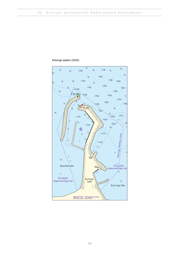
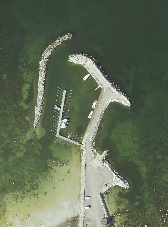
Planta do porto
Não usar para navegação. Veja todos os portos no mapa.
Ver no Nutimeri (Transpordiamet, opens in a new tab) — Transpordiamet
Cartas de navegação e sinalização oficiais, apenas para informação — não é um meio de navegação primário.
Instruções de aproximação
Based on a published sailing directions guideSpeed limit: laev peab liikuma minimaalse kiirusega, kuid mitte kiiremini kui 3 sõlme, ahtrilaine ei tohi tekkida. Vessel movements: laeva ümberpaigutamine on lubatud üksnes sadamakapteni teenistuse loal. Entry and departure ban: tuule kiirusel üle 12 m/s; nähtavusel alla 50 m.[2]
Use em conjunto com uma carta náutica atualizada e os avisos à navegação.
Depths and dimensional restrictions
The maximum permitted draught is 1.3 m. Published depths alongside are quay 1: 1.7 m, quay 2: 1.0 m, quay 3: 1.0 m, quay 4: 0.4 m and quay 5: 1.7 m. Depths are referenced to EH2000.[2]
Profundidades cais a cais (5)
| quay 1 and 5 | 1.7 m |
|---|---|
| quay 2 and 3 | 1.0 m |
| quay 4 | 0.4 m |
Fontes
- Sailing directions Lootsiraamat 4.2 — Suurupi poolsaarest Kaberneeme poolsaareni
- Sailing directions Lootsiraamat 4.2 — Suurupi poolsaarest Kaberneeme poolsaareni
Publicado em 12 Sept 2026 · revisão 4
Estatísticas históricas do vento
Prevailing winds
How often the wind blew FROM each direction, May–September 2021–2025.
Modelled data, not measured at the harbour
Rings: May (inside) → Sep (outside). Figure at the edge: share of the whole season.
The wind most often came from W (12 % of the season's hours).
- under 3 %
- 3–6 %
- 6–9 %
- 9–13 %
- 13–20 %
- 20 % or more
Regional model data cannot show how sheltered the harbour is, or how the wind moves around its piers and breakwaters.
Data as a table
| Wind from | May | Jun | Jul | Aug | Sep | Season |
|---|---|---|---|---|---|---|
| N | 4.2 % | 4.3 % | 2.7 % | 3.3 % | 4.6 % | 3.8 % |
| NNE | 3.4 % | 2.0 % | 2.1 % | 1.9 % | 2.9 % | 2.5 % |
| NE | 4.2 % | 2.7 % | 4.1 % | 3.5 % | 2.5 % | 3.4 % |
| ENE | 6.2 % | 5.2 % | 7.8 % | 5.3 % | 4.7 % | 5.8 % |
| E | 4.2 % | 4.9 % | 4.0 % | 4.8 % | 5.7 % | 4.7 % |
| ESE | 3.5 % | 3.7 % | 3.0 % | 4.6 % | 5.3 % | 4.0 % |
| SE | 3.1 % | 3.4 % | 4.5 % | 5.8 % | 9.3 % | 5.2 % |
| SSE | 3.3 % | 3.8 % | 4.7 % | 8.1 % | 11 % | 6.2 % |
| S | 4.8 % | 4.7 % | 3.5 % | 7.1 % | 8.0 % | 5.6 % |
| SSW | 5.8 % | 6.4 % | 7.1 % | 9.2 % | 8.1 % | 7.3 % |
| SW | 7.1 % | 9.9 % | 13 % | 10 % | 8.5 % | 9.7 % |
| WSW | 12 % | 13 % | 14 % | 12 % | 6.8 % | 11 % |
| W | 16 % | 14 % | 12 % | 9.8 % | 5.6 % | 12 % |
| WNW | 10 % | 10 % | 8.4 % | 6.8 % | 5.5 % | 8.2 % |
| NW | 5.7 % | 7.3 % | 5.3 % | 4.2 % | 5.7 % | 5.6 % |
| NNW | 5.0 % | 3.6 % | 2.6 % | 3.4 % | 5.2 % | 3.9 % |
| calm | 0.9 % | 0.9 % | 1.0 % | 0.3 % | 0.4 % | 0.7 % |
| % | 100 % | 100 % | 100 % | 100 % | 100 % | 100 % |
Calm: below 0.5 m/s; counted in the total, not in any direction. 18360 valid hours of 18360 expected.
Source: ERA5 reanalysis (ECMWF / Copernicus Climate Change Service), ~25 km grid · model grid point 8 km south-west of the harbour (59.500, 24.750) · May–September 2021–2025, UTC · 18360 valid hours of 18360 expected · Data retrieved 2026-10-07 · Contains modified Copernicus Climate Change Service information (ERA5), CC BY 4.0
Dados: fonte pública, registo atualizado em 30 Jul 2026.
Visitor observations
Sailors' experiences, not the harbour's official information.
Informação prática e documentos do porto
- Morada
- Harju maakond, Viimsi vald, Kelvingi küla, Kelvingi sadam, 74018
- Época de navegação
- 1. mai - 1. november
- Capitão do porto
- Avo Freibach
- Posição
- 59.55580° N, 24.83920° E
- Telefone
- +372 5032826
- avo.frei@gmail.com
Todos os serviços registados
Veesõiduki sildumise võimaldamine · WC · Slipi kasutamise võimaldamine · Joogivesi · Parkla · Internetiühenduse kasutamine · Elekter
Portos mais próximos
Distância em linha reta. O mais próximo não significa adequado ao seu barco.
Tallinn bay, Paldiski, Naissaar and Aegna, plus the western half of Lahemaa out to Kolga and Hara. Short legs and most services open year-round. Todos os portos em Harju county and Tallinn →
Suggest a video for this harbour
Add a 3–30 second video file or a YouTube link. Videos are reviewed before publication; a suitable short clip may become the page hero.