Kavaru sadam
Pärnu county and the Gulf of Riga · Liivi laht
Página deste porto em mervare.ee ↗
Num relance
- 0.8 mPermitted draughtpilot book
- 24 mMaximum lengthregister
- 4 mMaximum beamregister
- 0.8 mQuay depthregister
- 1 de abril – 31 de outubroNavigation periodregister
Permitted draught is the limit the sailing directions publish for entering; quay depth is the register's figure for the deepest quay — other quays may be shallower. Neither guarantees a berth that suits your boat.
Serviços
Ainda não existe uma lista confirmada de serviços. Isso não significa que não existam serviços.
Preços e disponibilidade
Preço não publicado — pergunte ao porto. Confirme com o porto os preços, a disponibilidade nas suas datas e os serviços incluídos.
Combine o lugar, o preço e a chegada diretamente com o porto.
Chegada
Pärnu maakond, Pärnu linn, Kavaru küla, Kavaru sadam, 88107
Arredores do porto
Não usar para navegação. Veja todos os portos no mapa.
Ver no Nutimeri (Transpordiamet, opens in a new tab) — Transpordiamet
Cartas de navegação e sinalização oficiais, apenas para informação — não é um meio de navegação primário.
Instruções de aproximação
Based on a published sailing directions guideUse em conjunto com uma carta náutica atualizada e os avisos à navegação.
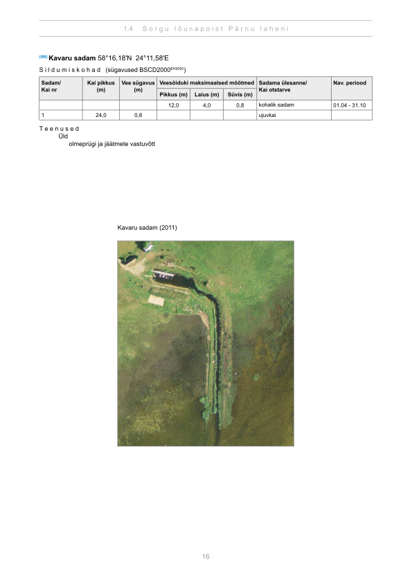
Depths and dimensional restrictions
The maximum permitted draught is 0.8 m. Published depths alongside are quay 1: 0.8 m. Depths are referenced to EH2000.[2]
Profundidades cais a cais (1)
| quay 1 | 0.8 m |
|---|
Fontes
- Sailing directions Lootsiraamat 1.4 — Sorgu lõunapoist Pärnu laheni
- Sailing directions Lootsiraamat 1.4 — Sorgu lõunapoist Pärnu laheni
Publicado em 12 Sept 2026 · revisão 4
Estatísticas históricas do vento
Prevailing winds
How often the wind blew FROM each direction, May–September 2021–2025.
Modelled data, not measured at the harbour
Rings: May (inside) → Sep (outside). Figure at the edge: share of the whole season.
The wind most often came from WSW (13 % of the season's hours).
- under 3 %
- 3–6 %
- 6–9 %
- 9–13 %
- 13–20 %
- 20 % or more
Regional model data cannot show how sheltered the harbour is, or how the wind moves around its piers and breakwaters.
Data as a table
| Wind from | May | Jun | Jul | Aug | Sep | Season |
|---|---|---|---|---|---|---|
| N | 4.7 % | 3.6 % | 2.7 % | 3.4 % | 4.1 % | 3.7 % |
| NNE | 3.8 % | 2.4 % | 2.2 % | 2.2 % | 3.8 % | 2.9 % |
| NE | 3.4 % | 2.1 % | 3.6 % | 2.9 % | 2.9 % | 3.0 % |
| ENE | 4.6 % | 2.3 % | 5.0 % | 5.2 % | 3.8 % | 4.2 % |
| E | 4.5 % | 3.9 % | 5.0 % | 3.4 % | 6.0 % | 4.6 % |
| ESE | 4.5 % | 4.3 % | 4.2 % | 4.6 % | 7.4 % | 5.0 % |
| SE | 4.5 % | 4.2 % | 3.8 % | 6.0 % | 9.4 % | 5.6 % |
| SSE | 3.7 % | 4.3 % | 4.1 % | 6.0 % | 7.8 % | 5.2 % |
| S | 5.7 % | 4.7 % | 4.9 % | 8.1 % | 7.1 % | 6.1 % |
| SSW | 6.8 % | 5.8 % | 4.9 % | 8.1 % | 7.0 % | 6.5 % |
| SW | 7.7 % | 11 % | 14 % | 11 % | 9.1 % | 11 % |
| WSW | 12 % | 15 % | 17 % | 11 % | 7.5 % | 13 % |
| W | 8.7 % | 11 % | 10 % | 9.3 % | 5.3 % | 8.8 % |
| WNW | 8.2 % | 8.5 % | 7.4 % | 8.4 % | 5.0 % | 7.5 % |
| NW | 9.7 % | 10 % | 5.9 % | 5.7 % | 5.6 % | 7.4 % |
| NNW | 7.1 % | 5.9 % | 4.3 % | 3.8 % | 7.8 % | 5.8 % |
| calm | 0.6 % | 0.8 % | 0.8 % | 0.4 % | 0.3 % | 0.6 % |
| % | 100 % | 100 % | 100 % | 100 % | 100 % | 100 % |
Calm: below 0.5 m/s; counted in the total, not in any direction. 18360 valid hours of 18360 expected.
Source: ERA5 reanalysis (ECMWF / Copernicus Climate Change Service), ~25 km grid · model grid point 4 km south-east of the harbour (58.250, 24.250) · May–September 2021–2025, UTC · 18360 valid hours of 18360 expected · Data retrieved 2026-10-07 · Contains modified Copernicus Climate Change Service information (ERA5), CC BY 4.0
Dados: fonte pública, registo atualizado em 18 Sept 2026.
Visitor observations
Sailors' experiences, not the harbour's official information.
Informação prática e documentos do porto
- Morada
- Pärnu maakond, Pärnu linn, Kavaru küla, Kavaru sadam, 88107
- Época de navegação
- 1. aprill - 31. oktoober
- Posição
- 58.26962° N, 24.19349° E
- Telefone
- +372 444 8160
- toomas.rohu@parnu.ee
- Site
- parnu.ee
Todos os serviços registados
Veesõiduki sildumise võimaldamine
Portos mais próximos
Distância em linha reta. O mais próximo não significa adequado ao seu barco.
Pärnu bay, the run out to Kihnu and Ruhnu, and the Pärnu river. Exposed to easterlies and westerlies — check the window before a long crossing. Todos os portos em Pärnu county and the Gulf of Riga →
Suggest a video for this harbour
Add a 3–30 second video file or a YouTube link. Videos are reviewed before publication; a suitable short clip may become the page hero.