Sillamäe sadam
Ida-Viru county · Soome laht
Page de ce port sur mervare.ee ↗
En bref
- 15.3 mPermitted draughtpilot book
- 319 mMaximum lengthregister
- 56 mMaximum beamregister
- 15.8 mQuay depthregister
- Toute l’annéeNavigation periodregister
Permitted draught is the limit the sailing directions publish for entering; quay depth is the register's figure for the deepest quay — other quays may be shallower. Neither guarantees a berth that suits your boat.
- laev peab liikuma minimaalse kiirusegaoriginal Estonian, not translated
- laeva ümberpaigutamine on lubatud üksnes sadamakapteni teenistuse loaloriginal Estonian, not translated
- enam kui 300 kogumahutavusega laevade üheaegne liikumineoriginal Estonian, not translated
- 12 m/sW – NE tuulte kiirusel üle 12 m/s kaide 1, 2, 9, 10 ja 11 juuresoriginal Estonian, not translated
- 10 m/slaevad pikkusega üle 255 m tuule kiirusel üle 10 m/s ja öösel kai 1 juuresoriginal Estonian, not translated
Services
- FuelUnknown
Tarifs et disponibilités
Tarif non publié — renseignez-vous auprès du port. Confirmez auprès du port les tarifs, les disponibilités à vos dates et les services inclus.
Convenez directement avec le port de votre emplacement, du tarif et de votre arrivée.
Arrivée
Ida-Viru maakond, Sillamäe linn, Kesk tn 2d, 40231
Plan du port
Ne pas utiliser pour la navigation. Voir tous les ports sur la carte.
View in Nutimeri (Transpordiamet, opens in a new tab) — Transpordiamet
Official navigation charts and markers, for information only — not a primary navigation aid.
Instructions nautiques
Based on a published sailing directions guideSõidugraafiku järgi liikuval parvlaeval on alati sadamasse sisenemise ja sealt väljumise eesõigus. Laevade üheaegsel sadamasse sisse- ja väljasõidul kehtib sadamast väljuva laeva eesõigus, v.a juhul kui tegu on hädaolukorraga. Speed limit: laev peab liikuma minimaalse kiirusega. Vessel movements: laeva ümberpaigutamine on lubatud üksnes sadamakapteni teenistuse loal. Entry and departure ban: enam kui 300 kogumahutavusega laevade üheaegne liikumine; w – NE tuulte kiirusel üle 12 m/s kaide 1, 2, 9, 10 ja 11 juures; laevad pikkusega üle 255 m tuule kiirusel üle 10 m/s ja öösel kai 1 juures.[2]
À utiliser avec une carte marine à jour et les avertissements de navigation.
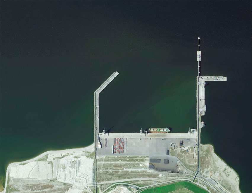
Depths and dimensional restrictions
The maximum permitted draught is 15.3 m. Published depths alongside range from 6.5 m to 15.8 m — shallowest at quay 7, deepest at quay 2. Depths are referenced to EH2000.[2]
Profondeurs par quai (13)
| quay 2 | 15.8 m |
|---|---|
| quay 1 | 15.7 m |
| quay 14 | 15.2 m |
| quay 13 | 15.0 m |
| quay 9 | 12.8 m |
| quay 10, 11 and 15 | 11.8 m |
| quay 4 | 11.7 m |
| quay 12 | 11.6 m |
| quay 5 | 11.5 m |
| quay 6 | 9.4 m |
| quay 7 | 6.5 m |
Sources
- Sailing directions Lootsiraamat 4.3 — Kaberneeme poolsaarest Narva jõeni
- Sailing directions Lootsiraamat 4.3 — Kaberneeme poolsaarest Narva jõeni
Publié le 12 Sept 2026 · révision 4
Statistiques historiques du vent
Prevailing winds
How often the wind blew FROM each direction, May–September 2021–2025.
Modelled data, not measured at the harbour
Rings: May (inside) → Sep (outside). Figure at the edge: share of the whole season.
The wind most often came from W (9.0 % of the season's hours).
- under 3 %
- 3–6 %
- 6–9 %
- 9–13 %
- 13–20 %
- 20 % or more
Regional model data cannot show how sheltered the harbour is, or how the wind moves around its piers and breakwaters.
Data as a table
| Wind from | May | Jun | Jul | Aug | Sep | Season |
|---|---|---|---|---|---|---|
| N | 8.3 % | 6.1 % | 4.3 % | 3.8 % | 5.4 % | 5.6 % |
| NNE | 5.6 % | 5.5 % | 5.1 % | 4.2 % | 3.9 % | 4.8 % |
| NE | 3.7 % | 3.2 % | 5.7 % | 4.8 % | 3.8 % | 4.2 % |
| ENE | 3.2 % | 3.2 % | 4.2 % | 4.2 % | 3.7 % | 3.7 % |
| E | 2.5 % | 2.9 % | 3.1 % | 3.2 % | 3.9 % | 3.1 % |
| ESE | 3.5 % | 3.3 % | 3.7 % | 4.1 % | 3.6 % | 3.6 % |
| SE | 4.1 % | 2.7 % | 5.2 % | 7.1 % | 9.3 % | 5.7 % |
| SSE | 4.8 % | 4.6 % | 4.4 % | 7.7 % | 14 % | 7.1 % |
| S | 6.2 % | 6.3 % | 6.0 % | 8.3 % | 9.5 % | 7.2 % |
| SSW | 6.2 % | 6.8 % | 5.4 % | 8.0 % | 8.9 % | 7.1 % |
| SW | 5.3 % | 5.2 % | 10 % | 11 % | 6.6 % | 7.7 % |
| WSW | 5.7 % | 6.2 % | 9.0 % | 7.6 % | 5.5 % | 6.8 % |
| W | 11 % | 11 % | 11 % | 8.3 % | 4.1 % | 9.0 % |
| WNW | 9.8 % | 13 % | 9.9 % | 6.8 % | 4.0 % | 8.8 % |
| NW | 9.8 % | 10 % | 7.5 % | 6.8 % | 6.6 % | 8.2 % |
| NNW | 10 % | 8.8 % | 5.1 % | 4.0 % | 6.7 % | 6.9 % |
| calm | 0.6 % | 0.6 % | 0.5 % | 0.5 % | 0.4 % | 0.5 % |
| % | 100 % | 100 % | 100 % | 100 % | 100 % | 100 % |
Calm: below 0.5 m/s; counted in the total, not in any direction. 18360 valid hours of 18360 expected.
Source: ERA5 reanalysis (ECMWF / Copernicus Climate Change Service), ~25 km grid · model grid point 8.6 km north of the harbour (59.500, 27.750) · May–September 2021–2025, UTC · 18360 valid hours of 18360 expected · Data retrieved 2026-10-07 · Contains modified Copernicus Climate Change Service information (ERA5), CC BY 4.0
Données : sources publiques, fiche mise à jour le 5 Aug 2026.
Visitor observations
Sailors' experiences, not the harbour's official information.
Informations pratiques et documents du port
- Adresse
- Ida-Viru maakond, Sillamäe linn, Kesk tn 2d, 40231
- Période de navigation
- 1. jaanuar - 31. detsember
- Capitainerie
- René Sirol
- Position
- 59.42296° N, 27.73925° E
- Téléphone
- +372 392 9150
- silport@silport.ee
- Site web
- www.silport.ee
Tous les services publiés
Veesõiduki lastimine ja lossimine · Veeliikluse korraldamine akvatooriumil ja sissesõiduteel · Veesõidukite pukseerimine ja jäämurdmine akvatooriumil · Veesõiduki sildumise võimaldamine · Kütus
Ports les plus proches
Distance à vol d’oiseau. Le plus proche n’est pas forcément adapté à votre bateau.
The eastern north coast out to Narva-Jõesuu, plus the Narva river. Harbours are sparse and legs are longer — plan a fallback. Tous les ports : Ida-Viru county →
Suggest a video for this harbour
Add a 3–30 second video file or a YouTube link. Videos are reviewed before publication; a suitable short clip may become the page hero.