Salmistu sadam
Harju county and Tallinn · Soome laht
Page de ce port sur mervare.ee ↗
En bref
- 1.7 mPermitted draughtpilot book
- 55 mMaximum lengthregister
- 3.5 mMaximum beamregister
- 2.3 mQuay depthregister
- 1 mai – 30 septembreNavigation periodregister
Permitted draught is the limit the sailing directions publish for entering; quay depth is the register's figure for the deepest quay — other quays may be shallower. Neither guarantees a berth that suits your boat.
- 3 knkiirus ei tohi ületada 3 sõlmeoriginal Estonian, not translated
- laeva ümberpaigutamine on lubatud üksnes sadamakapteni teenistuse loaloriginal Estonian, not translated
- 15 m/sNE - E tuule kiirusel üle 15 m/soriginal Estonian, not translated
- 1 mlaine kõrgusel üle 1 moriginal Estonian, not translated
Services
- Shore powerUnknown
- WaterUnknown
- SlipwayUnknown
Tarifs et disponibilités
Tarif non publié — renseignez-vous auprès du port. Confirmez auprès du port les tarifs, les disponibilités à vos dates et les services inclus.
Convenez directement avec le port de votre emplacement, du tarif et de votre arrivée.
Arrivée
Harju maakond, Kuusalu vald, Salmistu küla, Sadama tee 26, 74629
Plan du port
Ne pas utiliser pour la navigation. Voir tous les ports sur la carte.
View in Nutimeri (Transpordiamet, opens in a new tab) — Transpordiamet
Official navigation charts and markers, for information only — not a primary navigation aid.
Instructions nautiques
Based on a published sailing directions guideLaevade üheaegsel sadamasse sisse- ja väljasõidul kehtib sadamast väljuva laeva eesõigus, v.a juhul kui tegu on hädaolukorraga. Speed limit: kiirus ei tohi ületada 3 sõlme. Vessel movements: laeva ümberpaigutamine on lubatud üksnes sadamakapteni teenistuse loal. Entry and departure ban: nE - E tuule kiirusel üle 15 m/s; laine kõrgusel üle 1 m.[2]
À utiliser avec une carte marine à jour et les avertissements de navigation.
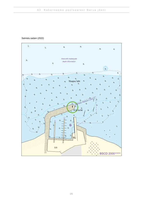
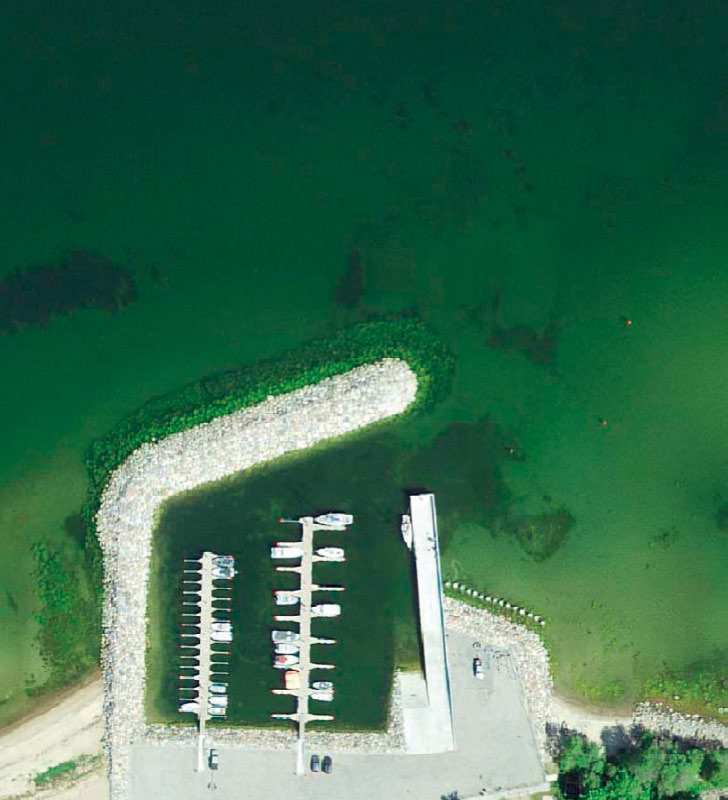
Depths and dimensional restrictions
The maximum permitted draught is 1.7 m. Published depths alongside are quay 1: 2.3 m, quay E-kai: 2.3 m and quay W-kai: 1.4 m. Depths are referenced to EH2000.[2]
Profondeurs par quai (3)
| quay 1 and E-kai | 2.3 m |
|---|---|
| quay W-kai | 1.4 m |
Sources
- Sailing directions Lootsiraamat 4.3 — Kaberneeme poolsaarest Narva jõeni
- Sailing directions Lootsiraamat 4.3 — Kaberneeme poolsaarest Narva jõeni
Publié le 12 Sept 2026 · révision 4
Statistiques historiques du vent
Prevailing winds
How often the wind blew FROM each direction, May–September 2021–2025.
Modelled data, not measured at the harbour
Rings: May (inside) → Sep (outside). Figure at the edge: share of the whole season.
The wind most often came from W (12 % of the season's hours).
- under 3 %
- 3–6 %
- 6–9 %
- 9–13 %
- 13–20 %
- 20 % or more
Regional model data cannot show how sheltered the harbour is, or how the wind moves around its piers and breakwaters.
Data as a table
| Wind from | May | Jun | Jul | Aug | Sep | Season |
|---|---|---|---|---|---|---|
| N | 4.0 % | 3.5 % | 2.2 % | 3.5 % | 4.8 % | 3.6 % |
| NNE | 3.2 % | 3.6 % | 2.5 % | 2.2 % | 2.5 % | 2.8 % |
| NE | 4.6 % | 2.9 % | 4.7 % | 3.4 % | 2.3 % | 3.6 % |
| ENE | 5.6 % | 5.1 % | 7.2 % | 5.0 % | 4.7 % | 5.5 % |
| E | 4.0 % | 4.4 % | 3.8 % | 4.7 % | 4.4 % | 4.3 % |
| ESE | 3.5 % | 4.2 % | 3.3 % | 5.3 % | 5.4 % | 4.4 % |
| SE | 3.3 % | 3.3 % | 4.8 % | 5.5 % | 9.5 % | 5.3 % |
| SSE | 4.1 % | 4.4 % | 5.1 % | 8.1 % | 12 % | 6.8 % |
| S | 4.9 % | 5.0 % | 3.9 % | 7.3 % | 9.3 % | 6.1 % |
| SSW | 6.1 % | 6.3 % | 7.8 % | 9.0 % | 8.7 % | 7.6 % |
| SW | 7.6 % | 9.1 % | 12 % | 11 % | 7.9 % | 9.5 % |
| WSW | 10 % | 11 % | 13 % | 11 % | 7.0 % | 10 % |
| W | 16 % | 15 % | 13 % | 9.7 % | 5.2 % | 12 % |
| WNW | 10 % | 10.0 % | 8.4 % | 6.6 % | 4.9 % | 8.0 % |
| NW | 6.4 % | 7.8 % | 5.5 % | 4.2 % | 5.7 % | 5.9 % |
| NNW | 5.5 % | 3.6 % | 2.5 % | 2.7 % | 5.2 % | 3.9 % |
| calm | 0.8 % | 0.6 % | 0.9 % | 0.8 % | 0.4 % | 0.7 % |
| % | 100 % | 100 % | 100 % | 100 % | 100 % | 100 % |
Calm: below 0.5 m/s; counted in the total, not in any direction. 18360 valid hours of 18360 expected.
Source: ERA5 reanalysis (ECMWF / Copernicus Climate Change Service), ~25 km grid · model grid point 6.6 km west of the harbour (59.500, 25.250) · May–September 2021–2025, UTC · 18360 valid hours of 18360 expected · Data retrieved 2026-10-07 · Contains modified Copernicus Climate Change Service information (ERA5), CC BY 4.0
Données : sources publiques, fiche mise à jour le 4 Sept 2026.
Vue depuis le sol
Visitor observations
Sailors' experiences, not the harbour's official information.
Informations pratiques et documents du port
- Adresse
- Harju maakond, Kuusalu vald, Salmistu küla, Sadama tee 26, 74629
- Période de navigation
- 1. mai - 30. september
- Capitainerie
- Madis Praks
- Position
- 59.49711° N, 25.36741° E
- Téléphone
- +372 5330 7301
- madis.praks@kuusalu.ee
Tous les services publiés
Veesõiduki sildumise võimaldamine · Slipi kasutamise võimaldamine · Muu · Elekter · Joogivesi
Ports les plus proches
Distance à vol d’oiseau. Le plus proche n’est pas forcément adapté à votre bateau.
Tallinn bay, Paldiski, Naissaar and Aegna, plus the western half of Lahemaa out to Kolga and Hara. Short legs and most services open year-round. Tous les ports : Harju county and Tallinn →
Suggest a video for this harbour
Add a 3–30 second video file or a YouTube link. Videos are reviewed before publication; a suitable short clip may become the page hero.