Ristna Lõunasadam
Hiiumaa · Läänemeri
Page de ce port sur mervare.ee ↗
En bref
- 0.5 mMaximum draughtregister
- 0.1 mMaximum lengthregister
- 2 mMaximum beamregister
- 15 juin – 30 septembreNavigation periodregister
Services
- Shore powerUnknown
- Wi-FiUnknown
- SlipwayUnknown
- ParkingUnknown
Tarifs et disponibilités
Tarif non publié — renseignez-vous auprès du port. Confirmez auprès du port les tarifs, les disponibilités à vos dates et les services inclus.
Convenez directement avec le port de votre emplacement, du tarif et de votre arrivée.
Arrivée
Hiiu maakond, Hiiumaa vald, Kalana küla, Ristna lõunasadam, 92230
Environs du port
Ne pas utiliser pour la navigation. Voir tous les ports sur la carte.
View in Nutimeri (Transpordiamet, opens in a new tab) — Transpordiamet
Official navigation charts and markers, for information only — not a primary navigation aid.
Instructions nautiques
Based on a published sailing directions guideÀ utiliser avec une carte marine à jour et les avertissements de navigation.
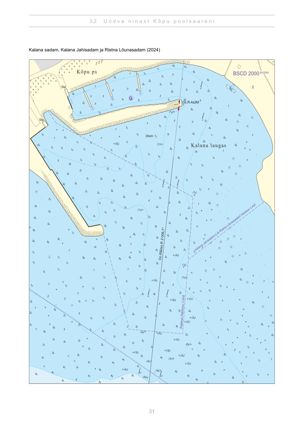
- Kalana sadam, Kalana Jahisadam ja Ristna Lõunasadam — aerial panorama (2024)Joel Tammet, estonia360.ee[1]
Sources
- Sailing directions Lootsiraamat 3.2 — Undva ninast Kõpu poolsaareni
Publié le 12 Sept 2026 · révision 3
Statistiques historiques du vent
Prevailing winds
How often the wind blew FROM each direction, May–September 2021–2025.
Modelled data, not measured at the harbour
Rings: May (inside) → Sep (outside). Figure at the edge: share of the whole season.
The wind most often came from SW (12 % of the season's hours).
- under 3 %
- 3–6 %
- 6–9 %
- 9–13 %
- 13–20 %
- 20 % or more
Regional model data cannot show how sheltered the harbour is, or how the wind moves around its piers and breakwaters.
Data as a table
| Wind from | May | Jun | Jul | Aug | Sep | Season |
|---|---|---|---|---|---|---|
| N | 5.3 % | 3.9 % | 4.1 % | 4.7 % | 8.0 % | 5.2 % |
| NNE | 4.1 % | 4.0 % | 3.0 % | 2.5 % | 4.1 % | 3.6 % |
| NE | 5.2 % | 4.0 % | 5.9 % | 4.0 % | 2.0 % | 4.2 % |
| ENE | 5.2 % | 3.3 % | 5.8 % | 4.0 % | 3.4 % | 4.3 % |
| E | 4.1 % | 2.7 % | 3.0 % | 3.2 % | 4.4 % | 3.5 % |
| ESE | 3.2 % | 2.4 % | 2.7 % | 3.1 % | 5.9 % | 3.4 % |
| SE | 3.4 % | 2.3 % | 2.3 % | 4.2 % | 9.8 % | 4.4 % |
| SSE | 3.9 % | 2.9 % | 3.3 % | 6.0 % | 7.1 % | 4.6 % |
| S | 4.7 % | 3.8 % | 3.7 % | 7.1 % | 7.3 % | 5.3 % |
| SSW | 10 % | 9.8 % | 8.2 % | 9.8 % | 8.0 % | 9.2 % |
| SW | 9.9 % | 15 % | 14 % | 13 % | 9.7 % | 12 % |
| WSW | 9.3 % | 12 % | 17 % | 11 % | 7.4 % | 11 % |
| W | 7.8 % | 7.4 % | 7.4 % | 8.2 % | 5.5 % | 7.3 % |
| WNW | 6.2 % | 8.5 % | 6.7 % | 5.9 % | 5.3 % | 6.5 % |
| NW | 7.8 % | 9.8 % | 5.1 % | 7.8 % | 5.6 % | 7.2 % |
| NNW | 9.0 % | 8.2 % | 7.3 % | 5.1 % | 6.3 % | 7.2 % |
| calm | 0.3 % | 0.4 % | 0.3 % | 0.2 % | 0.2 % | 0.3 % |
| % | 100 % | 100 % | 100 % | 100 % | 100 % | 100 % |
Calm: below 0.5 m/s; counted in the total, not in any direction. 18360 valid hours of 18360 expected.
Source: ERA5 reanalysis (ECMWF / Copernicus Climate Change Service), ~25 km grid · model grid point 9.4 km north of the harbour (59.000, 22.000) · May–September 2021–2025, UTC · 18360 valid hours of 18360 expected · Data retrieved 2026-10-07 · Contains modified Copernicus Climate Change Service information (ERA5), CC BY 4.0
Données : sources publiques, fiche mise à jour le 3 Jun 2026.
Vue depuis le sol
Visitor observations
Sailors' experiences, not the harbour's official information.
Informations pratiques et documents du port
- Adresse
- Hiiu maakond, Hiiumaa vald, Kalana küla, Ristna lõunasadam, 92230
- Période de navigation
- 15. juuni - 30. september
- Position
- 58.92159° N, 22.06261° E
- Téléphone
- +372 5123344
Tous les services publiés
Veesõiduki sildumise võimaldamine · Elekter · Parkla · Internetiühenduse kasutamine · Muu · Slipi kasutamise võimaldamine
Ports les plus proches
Distance à vol d’oiseau. Le plus proche n’est pas forcément adapté à votre bateau.
Hiiumaa and the Kärdla area. Mind the Hiiu shallows and Suursäär — check depths before you commit. Tous les ports : Hiiumaa →
Suggest a video for this harbour
Add a 3–30 second video file or a YouTube link. Videos are reviewed before publication; a suitable short clip may become the page hero.