Abruka sadam
Saaremaa and Muhu · Liivi laht
Page de ce port sur mervare.ee ↗
En bref
- 2.7 mPermitted draughtpilot book
- 56 mMaximum lengthregister
- 15 mMaximum beamregister
- 3 mQuay depthregister
- Toute l’annéeNavigation periodregister
Permitted draught is the limit the sailing directions publish for entering; quay depth is the register's figure for the deepest quay — other quays may be shallower. Neither guarantees a berth that suits your boat.
- laev peab liikuma minimaalse kiirusega, mille puhul ta säilitab juhitavuseoriginal Estonian, not translated
- laeva ümberpaigutamine on lubatud üksnes sadamakapteni teenistuse loaloriginal Estonian, not translated
- 15 m/sNE – SE-tuule kiirusel üle 15 m/soriginal Estonian, not translated
- 1 mlaine kõrgusel kai ääres üle 1 moriginal Estonian, not translated
- 50 mnähtavusel alla 50 moriginal Estonian, not translated
Services
- ShowerUnknown
- WCUnknown
- CaféUnknown
- Wi-FiUnknown
- LaundryUnknown
- SlipwayUnknown
Tarifs et disponibilités
Tarif non publié — renseignez-vous auprès du port. Confirmez auprès du port les tarifs, les disponibilités à vos dates et les services inclus.
Convenez directement avec le port de votre emplacement, du tarif et de votre arrivée.
Operated by SL Marinas
Links open the harbour operator's own website.
Arrivée
Saare maakond, Saaremaa vald, Abruka küla, Sadama Sadama, 93826
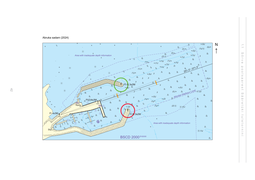
Plan du port
Ne pas utiliser pour la navigation. Voir tous les ports sur la carte.
View in Nutimeri (Transpordiamet, opens in a new tab) — Transpordiamet
Official navigation charts and markers, for information only — not a primary navigation aid.
Instructions nautiques
Based on a published sailing directions guideSõidugraafku järgi liikuval parvlaeval on alati sadamasse sisenemise ja sealt väljumise eesõigus. Muude laevade üheaegsel sadamasse sisse- ja väljasõidul kehtib sadamast väljuva laeva eesõigus, v.a juhul kui tegu on hädaolukorraga. Laev pikkusega üle 15 m, millel puudub vööripõtkur, peab sildumistöödel kasutama vedurlaeva abi. Sõidugraafiku järgi liikuval parvlaeval on alati sadamasse sisenemise ja sealt väljumise eesõigus. Muude laevade üheaegsel sadamasse sisse- ja väljasõidul kehtib sadamast väljuva laeva eesõigus, v.a juhul kui tegu on hädaolukorraga. Väikelaevad peavad laevade lähenemisel hoiduma telgjoonest nii kaugele, kui seda võimaldab nende endi meresõiduohutus. Speed limit: laev peab liikuma minimaalse kiirusega, mille puhul ta säilitab juhitavuse. Vessel movements: laeva ümberpaigutamine on lubatud üksnes sadamakapteni teenistuse loal. Entry and departure ban: nE – SE-tuule kiirusel üle 15 m/s; laine kõrgusel kai ääres üle 1 m; nähtavusel alla 50 m.[2]
À utiliser avec une carte marine à jour et les avertissements de navigation.
- Abruka sadam — aerial panorama (2023)Joel Tammet, estonia360.ee[1]
Depths and dimensional restrictions
The maximum permitted draught is 2.7 m. Published depths alongside range from 1.1 m to 3.0 m — shallowest at quay 7, deepest at quay 1. Depths are referenced to EH2000.[2]
Profondeurs par quai (8)
| quay 1 | 3.0 m |
|---|---|
| quay 2 | 2.9 m |
| quay 3 | 2.5 m |
| quay 4 | 2.2 m |
| quay 6 | 1.8 m |
| quay 5 | 1.5 m |
| quay 8 | 1.2 m |
| quay 7 | 1.1 m |
Sources
- Sailing directions Lootsiraamat 1.1 — Sõrve poolsaarest Sääretüki tuletornini
- Sailing directions Lootsiraamat 1.1 — Sõrve poolsaarest Sääretüki tuletornini
Publié le 12 Sept 2026 · révision 4
Statistiques historiques du vent
Prevailing winds
How often the wind blew FROM each direction, May–September 2021–2025.
Modelled data, not measured at the harbour
Rings: May (inside) → Sep (outside). Figure at the edge: share of the whole season.
The wind most often came from SW (12 % of the season's hours).
- under 3 %
- 3–6 %
- 6–9 %
- 9–13 %
- 13–20 %
- 20 % or more
Regional model data cannot show how sheltered the harbour is, or how the wind moves around its piers and breakwaters.
Data as a table
| Wind from | May | Jun | Jul | Aug | Sep | Season |
|---|---|---|---|---|---|---|
| N | 3.9 % | 2.9 % | 2.9 % | 3.4 % | 6.4 % | 3.9 % |
| NNE | 3.7 % | 2.1 % | 2.0 % | 1.9 % | 3.7 % | 2.7 % |
| NE | 4.1 % | 2.6 % | 3.0 % | 3.1 % | 1.8 % | 2.9 % |
| ENE | 4.4 % | 2.0 % | 4.2 % | 3.5 % | 3.1 % | 3.5 % |
| E | 4.5 % | 3.8 % | 5.8 % | 3.0 % | 4.3 % | 4.3 % |
| ESE | 5.2 % | 5.4 % | 4.1 % | 4.0 % | 6.6 % | 5.0 % |
| SE | 6.3 % | 5.2 % | 4.5 % | 7.2 % | 9.0 % | 6.4 % |
| SSE | 7.4 % | 8.1 % | 4.9 % | 7.4 % | 9.1 % | 7.4 % |
| S | 4.8 % | 4.7 % | 3.9 % | 6.4 % | 6.8 % | 5.3 % |
| SSW | 7.3 % | 4.6 % | 5.8 % | 8.7 % | 6.9 % | 6.7 % |
| SW | 10 % | 14 % | 16 % | 12 % | 10 % | 12 % |
| WSW | 9.8 % | 13 % | 17 % | 12 % | 7.6 % | 12 % |
| W | 7.2 % | 9.4 % | 9.2 % | 8.0 % | 6.9 % | 8.1 % |
| WNW | 6.5 % | 8.3 % | 6.2 % | 8.3 % | 5.5 % | 6.9 % |
| NW | 8.1 % | 8.3 % | 5.0 % | 5.7 % | 5.1 % | 6.4 % |
| NNW | 6.5 % | 5.3 % | 5.2 % | 4.7 % | 6.9 % | 5.7 % |
| calm | 0.3 % | 0.3 % | 0.6 % | 0.5 % | 0.3 % | 0.4 % |
| % | 100 % | 100 % | 100 % | 100 % | 100 % | 100 % |
Calm: below 0.5 m/s; counted in the total, not in any direction. 18360 valid hours of 18360 expected.
Source: ERA5 reanalysis (ECMWF / Copernicus Climate Change Service), ~25 km grid · model grid point 9.9 km north of the harbour (58.250, 22.500) · May–September 2021–2025, UTC · 18360 valid hours of 18360 expected · Data retrieved 2026-10-07 · Contains modified Copernicus Climate Change Service information (ERA5), CC BY 4.0
Données : sources publiques, fiche mise à jour le 11 Feb 2026.
Vue depuis le sol
Visitor observations
Sailors' experiences, not the harbour's official information.
Informations pratiques et documents du port
- Adresse
- Saare maakond, Saaremaa vald, Abruka küla, Sadama Sadama, 93826
- Période de navigation
- 1. jaanuar - 31. detsember
- Capitainerie
- Andrus Saat
- Position
- 58.16260° N, 22.52763° E
- Téléphone
- +372 4530140
- info@saarteliinid.ee
- Site web
- www.saarteliinid.ee
Tous les services publiés
Reisijate laevale mineku ja laevalt tuleku korraldamine · Veesõiduki sildumise võimaldamine · Internetiühenduse kasutamine · Kohvik/Restoran · Pesemisvõimaluste pakkumine · Slipi kasutamise võimaldamine · Pesupesemise võimaldamine · WC
Ports les plus proches
Distance à vol d’oiseau. Le plus proche n’est pas forcément adapté à votre bateau.
Saaremaa, Muhu, Abruka and Vilsandi. Depths in the Väinameri are modest — draft is the binding constraint here. Tous les ports : Saaremaa and Muhu →
Suggest a video for this harbour
Add a 3–30 second video file or a YouTube link. Videos are reviewed before publication; a suitable short clip may become the page hero.