Dirhami sadam
Lääne county · Väinameri
Página de este puerto en mervare.ee ↗
De un vistazo
- 3.7 mPermitted draughtpilot book
- 166 mMaximum lengthregister
- 12 mMaximum beamregister
- 3.5 mQuay depthregister
- Todo el añoNavigation periodregister
Here the published draught (3.7 m) is greater than the deepest quay depth (3.5 m): the sources disagree or measure different places. Confirm with the harbour before arriving.
Permitted draught is the limit the sailing directions publish for entering; quay depth is the register's figure for the deepest quay — other quays may be shallower. Neither guarantees a berth that suits your boat.
- minimaalne kiirus, mille puhul säilib aluse juhitavusoriginal Estonian, not translated
- laeva ümberpaigutamine on lubatud üksnes sadamakapteni teenistuse loaloriginal Estonian, not translated
- laeva ümberpaigutamisel on lootsimine kohustuslik, v.a haalamiseloriginal Estonian, not translated
Servicios
- WaterUnknown
- ShowerUnknown
- CaféUnknown
- FuelUnknown
- Wi-FiUnknown
- WasteUnknown
- SlipwayUnknown
- Bike hireUnknown
- RepairsUnknown
Precios y disponibilidad
Precio no publicado: consulte al puerto. Confirme con el puerto los precios, la disponibilidad en sus fechas y los servicios incluidos.
Acuerde directamente con el puerto la plaza, el precio y la llegada.
Llegada
Lääne maakond, Lääne-Nigula vald, Dirhami küla / Derhamn, Dirhami sadam, 91214
Plano del puerto
No apto para la navegación. Ver todos los puertos en el mapa.
View in Nutimeri (Transpordiamet, opens in a new tab) — Transpordiamet
Official navigation charts and markers, for information only — not a primary navigation aid.
Derrotero
Based on a published sailing directions guideSpeed limit: minimaalne kiirus, mille puhul säilib aluse juhitavus. Vessel movements: laeva ümberpaigutamine on lubatud üksnes sadamakapteni teenistuse loal; laeva ümberpaigutamisel on lootsimine kohustuslik, v.a haalamisel.[2]
Utilizar junto con una carta náutica actualizada y los avisos a los navegantes.
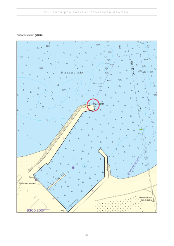
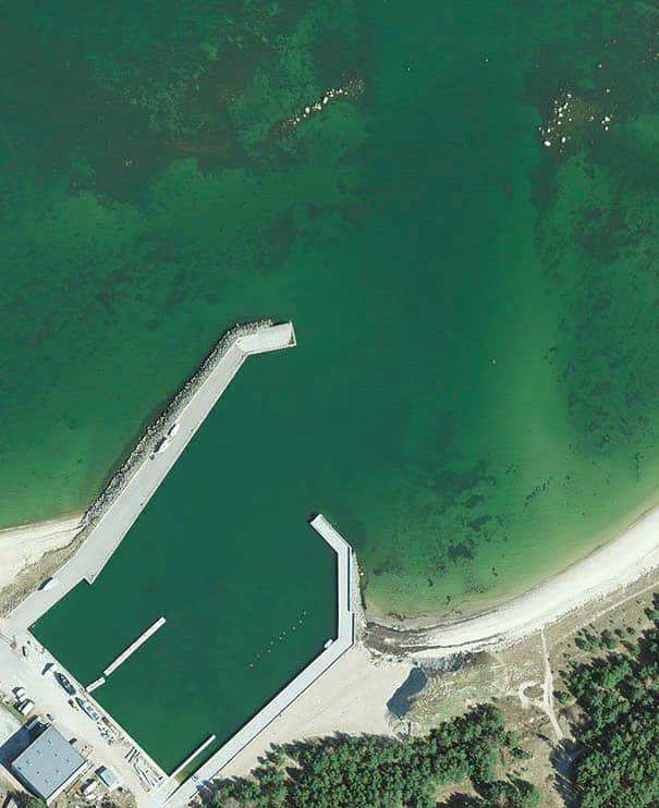
Depths and dimensional restrictions
The maximum permitted draught is 3.7 m. Published depths alongside range from 2.2 m to 3.5 m — shallowest at quay 8A, deepest at quay 4. Depths are referenced to EH2000.[2]
Profundidades por muelle (9)
| quay 4 | 3.5 m |
|---|---|
| quay 2 | 3.4 m |
| quay 1 | 2.9 m |
| quay 3 | 2.7 m |
| quay 5, 6 and 7 | 2.5 m |
| quay 8A and 8B | 2.2 m |
Fuentes
- Sailing directions Lootsiraamat 3.3 — Kõpu poolsaarest Põõsaspea neemeni
- Sailing directions Lootsiraamat 3.3 — Kõpu poolsaarest Põõsaspea neemeni
Publicado el 12 Sept 2026 · revisión 4
Estadísticas históricas del viento
Prevailing winds
How often the wind blew FROM each direction, May–September 2021–2025.
Modelled data, not measured at the harbour
Rings: May (inside) → Sep (outside). Figure at the edge: share of the whole season.
The wind most often came from SW (10 % of the season's hours).
- under 3 %
- 3–6 %
- 6–9 %
- 9–13 %
- 13–20 %
- 20 % or more
Regional model data cannot show how sheltered the harbour is, or how the wind moves around its piers and breakwaters.
Data as a table
| Wind from | May | Jun | Jul | Aug | Sep | Season |
|---|---|---|---|---|---|---|
| N | 5.2 % | 4.8 % | 2.8 % | 3.9 % | 6.4 % | 4.6 % |
| NNE | 4.1 % | 3.2 % | 3.5 % | 2.2 % | 3.8 % | 3.4 % |
| NE | 5.8 % | 3.2 % | 6.5 % | 3.9 % | 2.5 % | 4.4 % |
| ENE | 4.3 % | 2.8 % | 6.0 % | 4.8 % | 3.7 % | 4.3 % |
| E | 4.2 % | 3.6 % | 2.3 % | 3.5 % | 5.0 % | 3.7 % |
| ESE | 2.9 % | 2.4 % | 2.8 % | 3.8 % | 5.9 % | 3.5 % |
| SE | 2.4 % | 3.1 % | 3.3 % | 5.3 % | 9.3 % | 4.7 % |
| SSE | 3.8 % | 3.7 % | 3.4 % | 5.8 % | 9.9 % | 5.3 % |
| S | 7.3 % | 6.4 % | 4.8 % | 9.9 % | 6.6 % | 7.0 % |
| SSW | 7.8 % | 7.7 % | 6.1 % | 8.5 % | 8.3 % | 7.7 % |
| SW | 7.5 % | 11 % | 13 % | 11 % | 8.7 % | 10 % |
| WSW | 8.4 % | 10 % | 13 % | 11 % | 7.3 % | 10 % |
| W | 8.9 % | 11 % | 9.6 % | 7.9 % | 4.5 % | 8.3 % |
| WNW | 11 % | 12 % | 8.3 % | 7.1 % | 5.2 % | 8.6 % |
| NW | 10 % | 9.6 % | 8.3 % | 7.3 % | 6.5 % | 8.4 % |
| NNW | 5.6 % | 5.8 % | 5.1 % | 4.6 % | 6.3 % | 5.5 % |
| calm | 0.7 % | 0.3 % | 0.6 % | 0.2 % | 0.1 % | 0.4 % |
| % | 100 % | 100 % | 100 % | 100 % | 100 % | 100 % |
Calm: below 0.5 m/s; counted in the total, not in any direction. 18360 valid hours of 18360 expected.
Source: ERA5 reanalysis (ECMWF / Copernicus Climate Change Service), ~25 km grid · model grid point 4.3 km north of the harbour (59.250, 23.500) · May–September 2021–2025, UTC · 18360 valid hours of 18360 expected · Data retrieved 2026-10-07 · Contains modified Copernicus Climate Change Service information (ERA5), CC BY 4.0
Datos: fuentes públicas, ficha actualizada el 25 Jun 2025.
Visitor observations
Sailors' experiences, not the harbour's official information.
Información práctica y documentos del puerto
- Dirección
- Lääne maakond, Lääne-Nigula vald, Dirhami küla / Derhamn, Dirhami sadam, 91214
- Periodo de navegación
- 1. jaanuar - 31. detsember
- Capitanía
- VIKTOR ROHTLA
- Posición
- 59.21139° N, 23.50085° E
- Teléfono
- +372 4797221, +37256234523
- Correo electrónico
- info@dirhami.ee
- Sitio web
- www.dirhami.ee
Todos los servicios publicados
Veesõiduki lastimine ja lossimine · Veesõiduki sildumise võimaldamine · Reisijate laevale mineku ja laevalt tuleku korraldamine · Dušš · Telefon · Kütus · Joogivesi · Wi-Fi · Pisiremont · Prügivastuvõtt · Slipp · Jalgrattalaenutus · Kohvik/Restoran
Puertos más cercanos
Distancia en línea recta. El más cercano no significa adecuado para su barco.
Nõva, Dirhami, Haapsalu and the Matsalu approaches. Shallow, sheltered coast with small harbours close together. Todos los puertos: Lääne county →
Suggest a video for this harbour
Add a 3–30 second video file or a YouTube link. Videos are reviewed before publication; a suitable short clip may become the page hero.